Another winter month completes today and after a cold start it’s ended up being the norm; mild and occasionally wet.
January 2024 saw the warmest/mildest day I’ve ever recorded in a January.A cold first-half of January but a milder second-half. Quite a windy month especially around the named-storms.At least we had a decent dry spell in the month. The average for the month is 110mm. We’ll end it around the 109mm mark. So yes, pretty much average.
Thursday: A brief ridge of high pressure means a settled day. There will be some bright or sunny spells knocking around but these will tend to be quite hazy. Temperatures will be just a little bit above average but still feeling a little cool. Max 8°C Min 4°C
Friday: A cloudy day with the cloud thick enough to produce some light rain or drizzle and low-cloud on the hills. We’re introducing southwesterly winds which will be very moist and bring with it some very mild air. Max 13°C Min 10°C
Much milder than average after Thursday, especially so on Friday.
Weekend: Mild with the chance of rain.
Saturday: Generally overcast with a weakening band of rain moving south. Mild and windy. Max 12°C Min 8°C
Sunday: Very little change as the band of patchy rain stalls across the region. Not much brightness expected, windy and still mild. Max 12°C Min 7°C
Outlook: Little change. We will stay on the mild side of the Jet Stream. Mostly cloudy with a mild southwesterly airflow bringing patchy rain or drizzle. Perhaps a little more unsettled towards the end of the week. Then, a little cooler from the north as we approach the 10th of February. The wait for our next proper cold spell goes on.
The Jet Stream will be centred across Northern parts of the UK. So we’re on the milder side and will flirt with rain at times for the first half of next week. More turbulent towards the end of next week.
Follow @ChadWeather on X for the latest forecasts and warnings.
Thanks,
Jon
Forecast Issued: Wednesday the 31st January 2024 at 5pm.
It’s been a turbulent week. 7 days. 2 named-storms. We’ve now had 10 storms this season. Will we see more before winter is out? Probably yes, but currently no sign of one in the immediate future. Also, little sign of wintry conditions with even frosts redundant.
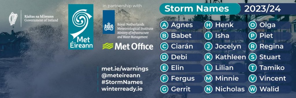
Storm names for this season
Unfortunately though, there will be more rain and not much in the way of sunshine, bar Friday.
Thursday: Cloud will have spread in from the southwest overnight. So it will be a wet morning with showery rain moving northeast. Bit of a dry spell and then into the afternoon and evening further showers will move in from the southwest. We are introducing a warm sector though, so it will be very mild for the time of year. Max 13°C Min 8°C
After a very mild Thursday, colder air arrives during the early hours of Friday.
Friday: We lose the warm air as cold fronts move through the region. These will bring some showers for the morning which should soon disappear and with a ridge of high pressure building from the south, it should be a much better day with sunny spells but remaining breezy and notably cooler. Cold overnight with a ground frost. Max 8°C Min 2°C
Windy again on Friday but sunny spells are expected
Weekend: Weather systems to the northwest, high pressure to the south of the UK.
Saturday: A weak cold-front will move through the region bringing a spell of rain but this is not expected to last too long as it will weaken. Quite breezy. Max 9°C Min 5°C
Sunday: A mostly cloudy day as expected and again it will be another breezy one. Just a chance that the cloud might be thick enough for a little bit of drizzle at times as another weather front decays over the region. A little milder. Max 11°C Min 6°C
Outlook: It’ll be mild at first with temperatures into double-figures. The week does look quite unsettled though with rain at times and temperatures slowly cooling off slightly as the week goes on. But no significant cold or frosts are expected and at the moment it won’t be windy enough for any more named-storms.
Mild for most of next week. No sign of any snow returning.
Follow @ChadWeather on X for the latest forecasts and warnings.
Thanks,
Jon
Forecast issued: Wednesday the 24th of January 2024 at 7:23pm.
It’s been a cold week, very cold at night and snow fell across the region during Tuesday. I know it’s winter and nothing new but we don’t get these wintry spells as often as we used to. Certainly feels that way, so whether you love the snow or crisp winter sunshine it’s nice to have a seasonal spell of weather, rather than the relentless rain and wind. Well, unfortunately the latter is set to return with the potential for some very windy days over the next 7 days.
I’ve spent today walking around Heaton Park. Frost or snow on the ground, Arctic air blue skies and little to no wind make for the best days. We definitely don’t get many days like today that’s for sure! Got to make the most of it.
The 17th green at Heaton Park
So, after little rainfall over the last 15 days, including 7 dry days, rain is set to return to bring a wet 4 or 5 days next week.
Only 8.8mm of rain over the last 15 days as we experienced much-needed drier weather
Thursday: Last night could well have been the coldest night of the winter so far with lows of -8°C rurally. This is helped when snow-cover is present, cooling the air further. Despite the cold and frosty start it will be another stunning day with wall-to-wall sunshine. There is a chance of some snow showers through the region into the late-evening. Another cold night to come. Max 2°C Min -5°C
Possible snow showers later on Thursday but nothing major.
Friday: Frosty start then another dry day with sunny spells becoming hazy later as the wind swings southwesterly and change is on the way. Patchy frost in the evening lifting later as temperatures slowly rise and cloud rolls in. Max 4°CMin 1°C
Back into double-figures on Sunday. The cold and snow long forgotten.
Weekend: Milder and wetter.
Saturday: Cloudy but hopefully staying dry for the morning. Drizzle then patchy rain will move in during the afternoon. Less cold, temperatures rising steadily during the day, but with it becoming windy it will still feel cold. Max 6°C Min 5°C
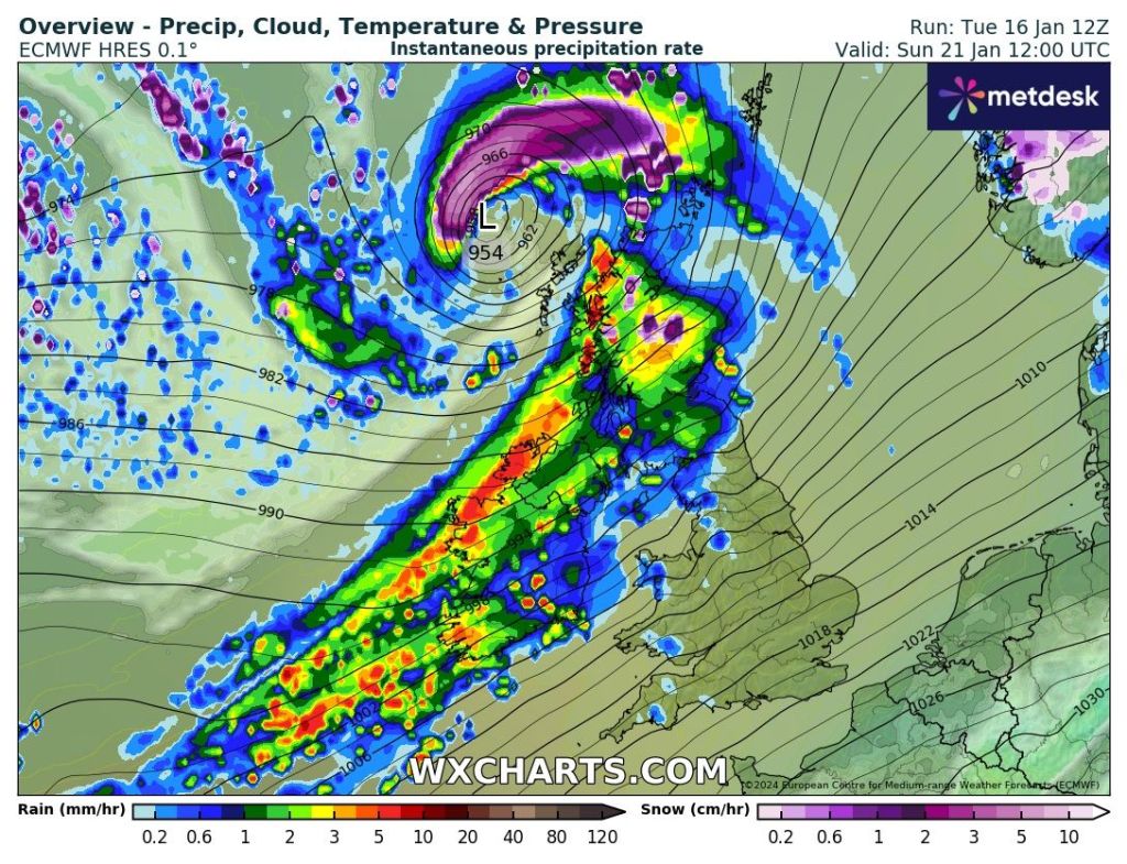
Sunday: Mostly cloudy then a deep area of low pressure will bring much milder temperatures, wind and rain. Warning already in place. Max 11°C Min 8°C
Sunday 06:00 to 23:59 see the region under a weather warning for strong windsVery windy and wet later on Sunday
Outlook: Temperatures above normal, especially on Tuesday where we could see values scrape into the teens. A wet week with rain or showers at times and turbulent with Tuesday night into Wednesday showing up as being potentially very windy with gusts to 50 mph. Hopefully high pressure will build back in for a drier and sunnier end to the month.
Follow @ChadWeather on X for the latest forecasts and warnings.
Thanks,
Jon
Forecast Issued: Wednesday the 17th January 2024 at 2:50pm.
I have weather records for the last 11-12 years. 2023 ranked top when it comes to overall average temperatures.
2023 10.7°C 2022 10.5°C 2014 10.2°C
I went and conducted my second tornado site investigation on Sunday to fill in the gaps of missing data. Again, a lot of damage to property, ridge and slate tiles missing. Also trees damaged from twisted, ripped off branches to full uproots. Here’s a selection of the photos from that day.
Tornado damage from recent site investigationHigh pressure firmly in charge on Friday like it has been most of this weekbut it’s been a mostly cloudy high with only Tuesday the day offering some decent amounts of sunshine.As we enter next week it looks like a battle will commence. Cold air with snow showers from the north vs. milder air from the south-west bringing rain, preceded by snow.Starting to look like the rain-bearing fronts will push in from the south-west midweek which could lead to a snow-event as it bumps into the cold air, especially on its leading edge. One to watch for sure.Maybe another similar set-up by the Friday. Snow then rain this time and then milder?
So as you can see. Next week looks a lot more complex than this week has been. This week being dominated by high pressure means it can be easy to predict plenty of dry weather although predicting cloud amounts and where those breaks appear can be a challenge. Even a large high can be cloudy and have cloud thick enough for drizzle. Predicting that isn’t easy either.
So will it snow next week? The chances are increasing and certainly more precipitation seems to be in the mix and when we have cold air in place at this time of the year, snow cannot be ruled out. So, watch out for updates on X.
Thursday: Mostlycloudy with a few breaks here and there and also the odd patch of drizzle. Cool. Max 6°C Min 3°C
Friday: Still cloudy but the cloud should not be as thick so drizzle unlikely and more bright spells possible. Lighter winds and a little cooler. Max 5°C Min 1°C
Weekend: Colder air is coming.
Saturday: Another cloudy day and with westerly winds some patchy rain or drizzle could return, especially later in the day. Max 6°C Min 2°C
Sunday: Little change initially with cloudy skies and areas of drizzle. Later in the day the winds will turn more northerly or northwesterly and allow colder, Arctic air to filter south behind cold fronts. Frosty overnight as skies clear. Max 6°C Min -1°C
Arctic air is coming.
Outlook: Sunny and cold to start with a few wintry showers on Tuesday. Wednesday could well see sleet and snow push up from the southwest. Where the low pressure tracks will determine how the weather pans out for the remainder of the week and of course which areas will see snow. Look out for updates on X.
Follow @ChadWeather on X for the latest forecasts and warnings.
Dew points dropping to -6°C as colder air comes down from the north later on Sunday into Monday.
Thanks, Jon
Forecast Issued: Wednesday the 10th of January 2024 at 6pm Images: http://www.wxcharts.com& the Met Office.
Happy New Year everyone. All the very best for 2024. I hope you had a great Christmas despite the relentless rain. It’s rained for the last 17 days straight, bringing 145.4mm. But, I do have some good news. Much drier weather is on the way and it will also be turning colder. The media has picked up on this and are already talking about snowmageddon {rolls eyes}. For now there is no sign of any significantsnow event.
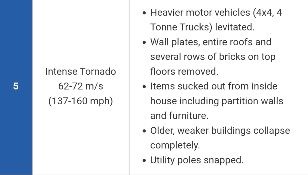
The big talking point since my last blog 2 weeks ago was the tornado that struck parts of Eastern Manchester. Notably, Stalybridge, Copley and Carrbrook. With this location only being around 6 miles away from my house, I did a site investigation for TORRO to plot the damage that I could find and there was a lot. TORRO had already been to the site and initially classed it as a maximum T5 rating which is staggering with estimated wind speeds of 137-160mph. Likely to be the strongest tornado for 17 years (not including the Jersey tornado which was a T6).
T5 – initial rating, as the possible maximum strength of the tornado on the evening of 27/12/2023 at around 23:05.Trees down in CopleyMoretrees down in Copley
The tornado investigation is still on-going but hopefully it won’t be long before it is finalised.
December was a very wet month and mild even after a cold start. In fact the 205mm made it the wettest December I’ve ever recorded in my 12 years of weather records.
A wet December 2023
There certainly won’t be any tornadoes or wild weather is the near future. High pressure is about to build in across the UK and we will enter a decent 7-10 day spell of mostly, if not completely, dry weather but colder air will accompany this pattern change. Cold enough for snow? Not far off but you need precipitation for that and there won’t be much around. Possible fog would only be the troublesome weather event over the coming days.
A transition to cold air will take place later this week.
Thursday: A cloudy morning is expected with a few showers. Drier with some bright spells into the afternoon. Winds falling lighter later. Cooler. Max 7°C Min 2°C
Friday: Mostly cloudy and winds will eventually turn north-westerly so it’ll be a little cooler (signs of change). Can’t rule out some showers out towards the west with perhaps the odd one sneaking inland. Max 6°C Min 2°C
Weekend: Drier (yeah!), colder with a risk of fog.
Saturday: A cloudy start with a few bright spells appearing. Chilly. Patchy frost overnight. Winds generally light. Max 5°C Min 1°C
Sunday: Cold setting in now, with mist or fog lifting into low-cloud. Looks like any sunshine will be a rare. Dry with a patchy frost returning overnight with some misty conditions. Max 3°C Min 0°C
Welcome Dryness: High pressure in control next week
Outlook: A fresh east or north-easterly wind will pick up which will help break up the cloud leading to sunny spells during the day and frosts at night. Looks dry all week. Perhaps snow showers later in the week drifting in from the North Sea and over the Pennines. But, as for now, cold and dry is the order of the week and no significant snow is expected but finally something more seasonal and relief from the deluge.
Lengthy dry & cold spell ahead. Once the high releases its grip it could well be a battleground of cold (snow) vs. mild (rain).
Follow @ChadWeather on X for the latest forecasts and warnings.
Thanks,
Jon
Forecast Issued: Wednesday the 3rd of January 2024 at 6pm.
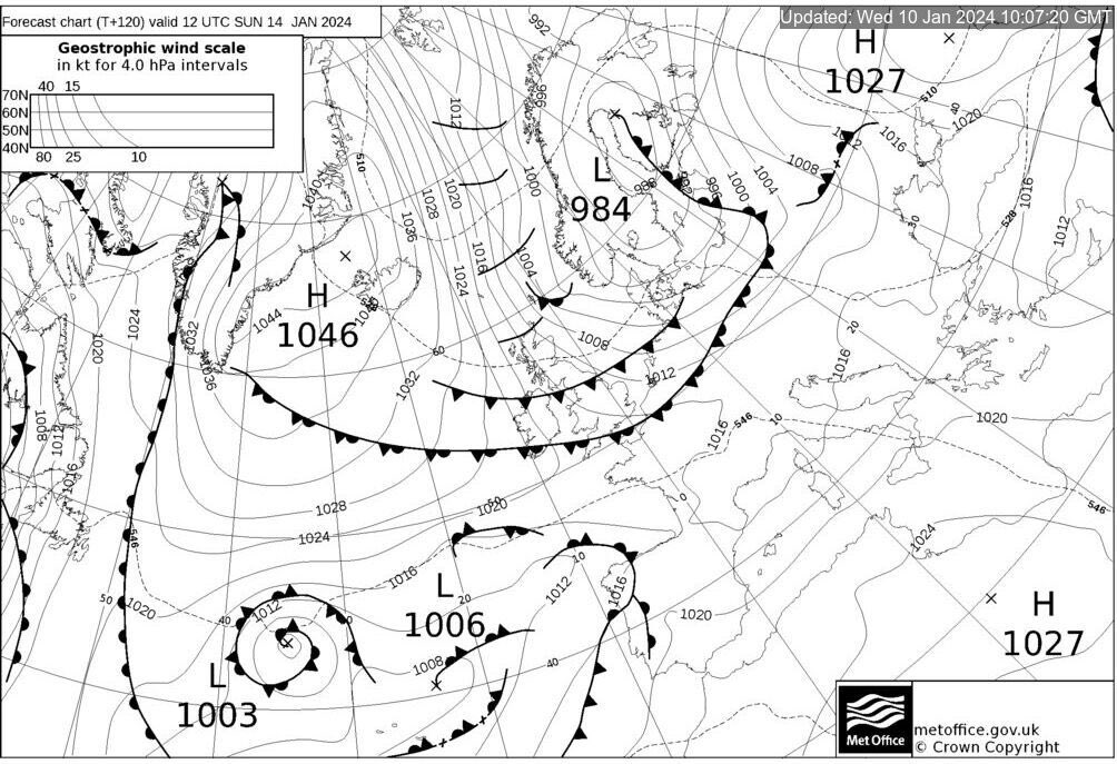
We are in for a spell of very windy weather. Gales or even severe gales in exposed places. The low pressure to our northeast has been named Storm Pia by the Danish Met Institute. It’s expected to be a windy 48 hours.
Weather warning in place for strong winds on Thursday up till 9pm
Christmas. Will it be white? Despite a few hints last week at something colder for the festive day, this has now backed off, so a mild-ish and breezy Christmas Day looks the most likely outcome.
A turbulent Thursday with a risk of gusts to 70mph in parts of the region
Thursday: Storm Pia to our northeast and a large area of high pressure out in the Atlantic will mean a real squeeze in the isobars across the region. Cloudy to start with some rain, then turning showery with some bright spells. It will be very windy throughout especially to the east of the hills and also during the first half of the day, with a warning in place. Widely 40-50mph and possibly 60-70mph on the eastern side of the Pennines. Max 10°C Min 7°C
So close to the cold air…..Friday remains mild on the thermometer
Friday: Rain to start which will hopefully ease away to the east into the afternoon. Still very windy, with 40mph gusts and still mild for the time of year. Max 10°C Min 8°C
Weekend: Mild, windy and some more rain to come.
Saturday: Generally cloudy and windy with patchy rain or drizzle, especially on western-facing hills. Very mild. Max 12°C Min 8°C
Christmas Eve (Sunday): Cloudy with pulses of rain, some drier spells in between, brought in on a steady southwesterly breeze. This airflow will bring some very mild temperatures once again. Max 13°C Min 8°C
Christmas Day (Monday): A better day in prospect. Earlier showers should ease away to a breezy day with some sunny spells. It will be a little cooler but there is no chance of snow this year I’m afraid. Max 9°CMin 5°C
Outlook: Remainingquite unsettled with bouts of rain or showers at times, coming in on the Jet Stream from the west. Temperatures will remain around average or maybe just a little bit above for the time of year before turning a little bit cooler as we head towards the end of 2023. No sign of any significant cold or snow.
Thanks as always, for stopping by to read my weekly blog. I hope you enjoyed it this year and find it useful. I hope you all have a lovely Christmas and I wish you all the best in 2024.
Follow @ChadWeather on X for the latest forecasts and warnings.
Thanks,
Jon
Forecast Issued: Wednesday the 20th of December 2023 at 5:05pm.
Christmas is coming and of course, the talk of a White Christmas is on everyone’s lips. No doubt you’ll see the over-the-top nonsense in the mainstream media but how are our chances looking, realistically?
A cold plunge in the run-up to Christmas Day will get our White Christmas hopes up
The latter part of this week, will be mild and frosts are not expected. It’s later next week that eyes turn to the north or northwest to the possibility of colder air drifting down across the UK, increasing the chance of some snow. It won’t be severe cold but cold enough for some wintry precipitation. Remember we only need one snowflake to call it a White Christmas officially.
GFS Model: This currently goes out to Christmas Day and shows snow-cover quite widely ECMWF HRES Model: As far as we currently can go is up to the 23rd and snow-cover is less widespread but depths are higher highlighting wintry showers on a NNW’ly.
Thursday: Cloudy to start with patchy rain moving west to east. It should become drier and eventually a bit brighter during the morning. Odd shower possible into the afternoon. Less cold. Max 9°C Min 3°C
Friday: Cloudy with a few bright spells here and there. Windy but this wind will be dragging in much milder air as the day goes on. It should be dry at least which is what we need right now. Max 11°C Min 7°C
Weekend: Mostly cloudy with brisk winds.
Saturday: Low pressure to the northwest and high pressure to our south means we will be in between with gusty, moist southwesterly winds. These will bring a lot of cloud, perhaps some hill-drizzle but most areas dry. Mild. Max 12°C Min 7°C
Sunday: Cloudy but dry to start. As the day progresses weather fronts to our northwest will slowly slip southeast bringing the increased risk of some light rain or drizzle. Windy and mild once again. Max 11°C Min 7°C
Outlook: We start the week wet and in the mild air still. As the week progresses, and it will be a windy week, the Jet Stream will slip further and further, albeit slowly, south. This will allow cooler and then cold air to slip down from the north or northwest. In the few days leading up to Christmas, wintry showers are likely, so some snow is possible on higher ground. If this lasts until Christmas Day, 2023 could well be officially a White Christmas. Look out for updates on X (@ChadWeather).
A change to colder air looks likely in the run-up to Christmas Day
Follow @ChadWeather on X for the latest forecasts and warnings.
Thanks, Jon
Forecast Issued: Wednesday the 13th of December 2023 at 7:30pm Images: http://www.wxcharts.com
A chilly and wet first half of November with only 1 dry dayA drier last third of November with a final week of cold and snowy conditions
After the cold spell, and some snow early in winter, the weather has slowly returned to what we are accustomed to. Rain. Less cold and a lack of sunshine. But today {Wednesday} was a brief cold and frosty day again. I certainly prefer those crisp blue skies even if it’s Baltic. And of course, I’m partial to a snowflake or ten.
A lovely day at Heaton Park on Wednesday
We saw snowfall this week, nice way to start winter, just like the old days
Thursday: Cloudy with pulses of heavy rain moving north-north-east, especially into the afternoon. Brisk winds will become gusty (35mph) with a slightly milder, but still feeling cold airflow after a cold 24 hours prior. Max 7°C Min 6°C
Friday: Low pressure in charge bringing bands of showery rain. The odd bright spell in between but like gold-dust. Breezy at times especially during showers. Milder. Max 9°C Min 6°C
Weekend: Dominated by unsettled conditions.
A soggy outlook with a couple of inches of rain expected over the next 7-10 days
Saturday: It’s a bit of a rinse and repeat, with showers or longer spells of rain coming in from the west after a dry start in the east. Remaining windy. Should sneak double-digits in a few favourable spots. Max 10°C Min 7°C
Sunday: Yet more rain is expected. Mild and breezy. Groundhog day. Max 9°CMin 6°C
Outlook: Little change into the first half of next week with the Jet Stream bringing bouts of rain. Signs of something less wet, cooler and not as mobile from midweek with a ridge of high pressure building leading to some drier conditions but mist or fog likely as winds slacken.
Follow @ChadWeather on X for the latest forecasts and warnings.
Winter officially, and meteorologically-speaking, starts on Friday and we enter it with temperatures well-below average and with a moderate frosts on the go, but, snow is what we all want, yeah? Well it’s not everyone’s favourite ingredient and it looks like this lengthy cold spell is going to be wasted when it comes to a decent snowfall.
Remember to ignore the fake news when it comes to the media and snowfall. It’s a circus out there.
Thursday: Cold and frosty with some localised mist or fog which might be slow to clear. Otherwise dry with sunny spells. A little breezy. Max 3°C Min -4°C
Friday: Similar pattern continues. Sunny by day, once fog/low-cloud lifts, frosty by night. Dry. Max 3°C Min -4°C
Weekend: Perhaps more in the way of cloud with the chance of some wintry showers.
Not much precipitation expected over the coming days with most of the wintry showers affecting the coasts. Any that drift inland will fall as sleet or snow.
Saturday: Early freezing fog will clear to bright or sunny spells but some wintry showers, snow above 150M, could be knocking around. Hard to say at this stage but more possible than earlier in the week.A bitter day. Max 2°C Min -3°C
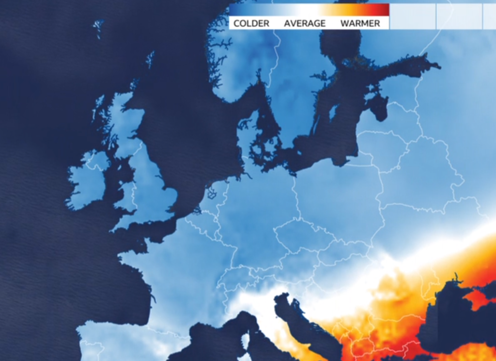
BBC Weather: Most of Europe colder-than-average this week
Sunday: Cloudier with some bright spells and again the chance of some scattered wintry showers. Nothing significant. Max 3°C Min -2°C
Outlook: We remain in the cold air, so more frosts to come but currently the models show a change will arrive around the 6th/7th of December, as we switch to a more south-westerly airflow bringing less cold air and eventually some rain and wind. It will have been a cold start to winter and disappointing to not have taken advantage of this and had some decent snowfall. Knowing our winters, the next cold spell will be March 😂.
Turning less cold as we enter the second week of December
Follow @ChadWeather on X for the latest forecasts and warnings.
As always thanks for reading.
Thanks,
Jon
Forecast Issued: Tuesday 28th November 2023 at 7:38pm
Still no 600-feet tall wall of snow on the way 😀 but our first cold snap as winter approaches is. Northerly winds will bring frost(s) and clearer blue skies with welcome sunshine but more importantly we’ve lost the relentless rain with high rainfall totals.
Tuesday was only our second day this month without measurable rainfall. So we need a break. There is still some rain around in this forecast but the general theme ahead is drier.
Only 2 days without rainfall so far in November
Thursday: A windy (30mph gusts) and cloudy day with some patchy rain. A more organised band of rain will sink south on a cold-front into the evening, pushing away the mild air and temperatures will fall away. Max 12°C Min 4°C
Colder air sinks south Thursday eveningSpot the cold-front sinking south on Thursday evening
Weekend: Cold but milder air to return?
Friday: Cold Arctic air will slowly filter south, and with the windchill it will feel like a couple of degrees above freezing. The north-westerly wind will be gusty at times. Sunny spells with some cloud, especially out west. Clear skies and lighter winds overnight will lead to a frost forming. Max 6°C Min -2°C
A frosty Friday night on the cards
Saturday: A frost to start then a cold but dry day with sunny spells and lighter winds. Frost likely to set in again into the evening and first part of the night but cloud could well lift temperatures later in the night. Max 5°C Min 0°C
Sunday: Depending on cloud-cover it could be another frosty start in places. Cloud is expected to topple down from the north-west making any sunshine hazy then lead to a cloudy afternoon. With the lack of sunshine it will feel cold still, despite less cold air feeding in. Patchy rain possible later into the evening. Max 6°C Min 3°C
Outlook: What the weather brings next week, is not certain. It’s more favourable to turn slightly milder again from the west with some showery rain and with some colder spells from the north-west.
But, some computer models today are signalling for an easterly wind to set in. Less likely to happen but if it were to lock-in, it will become much colder with a sharp wind, and perhaps cold enough for a few snow flurries. For updates on this, look out for my posts on X.
Could we see an easterly airflow arrive as we head towards the start of winter
Follow @ChadWeather on X for the latest forecasts and warnings.
Thanks again for reading.
Jon
Forecast Issued: Wednesday the 22nd of November 2023 at 12:32pm.